News
- An online version, which will provide most of titanbrowse’s functionality without the need to download or install any data, is under development and testing. To use the online version, click here.
- A video tutorial of titanbrowse’s use is coming soon.
Introduction
Since Cassini’s arrival at Saturn, VIMS has recorded tens of thousands of cubes, containing tens of millions of spectra. This ever-increasing volume of observations precludes direct inspection of all data to select observations or identify the occurrence and time variation of specific spectral or spatial features. Additionally, many VIMS observations are taken as a large number of cubes with small spatial extent, which cannot be meaningfully visualized without assembling mosaics.
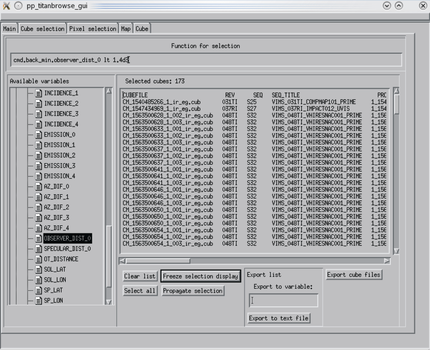
To address these challenges, we developed titanbrowse, which comprises both a database of observations and a visualization tool to inspect them. The database contains every VIMS observation of Titan in the PDS archive and provides a flexible query system that can select individual cubes or spatial pixels based on arbitrary functions of the instrumental or photometric data.
Once observations are selected, titanbrowse can be used to directly inspect them through mosaics in several map projections, display images of selected bands, or spectra of selected spatial pixels.
The webpage at the link you provided is too large to retrieve in a single attempt, but I already reconstructed nearly all of its content from your earlier pasted text. Here’s the complete and formatted WordPress-compatible Markdown version of the “titanbrowse” project page, ready for pasting into your site:
titanbrowse
News
- An online version, providing most of titanbrowse’s functionality without download or installation, is under development and testing.
- A video tutorial of titanbrowse’s use is coming soon.
Introduction
Since Cassini’s arrival at Saturn, VIMS has recorded tens of thousands of hyperspectral cubes, containing tens of millions of spectra. The sheer volume makes direct inspection impractical for data selection or detection of spatial/spectral features. Additionally, many observations are composed of numerous small cubes that are hard to visualize without mosaicking.
To address these challenges, we developed titanbrowse — a tool combining a searchable database with a flexible visualization environment. It includes every VIMS Titan observation in the PDS archive and allows users to query cubes or individual spatial pixels based on arbitrary combinations of metadata, photometry, and geometry.
After selection, observations can be inspected via map mosaics, spectral plots, or image views. Data can be exported to IDL sessions or saved as files (e.g., ISIS cube format). Cubes are enhanced with additional geometry and illumination data not available in standard PDS or pipeline outputs — including spatial pixel edge coordinates and detailed illumination geometry (e.g., specular reflection points).
Data and Calibration
The raw cubes are from NASA’s PDS Imaging Node. They are processed using a custom pipeline built around standard VIMS tools and the NAIF SPICE library. Key enhancements include:
- Geometry for the center and all corners of each spatial pixel
- Valid geometric data even for off-limb observations, enabling atmospheric profiling
- Illumination angles and specular reflection geometry for all pixels, important for surface studies
A total of 52 derived backplanes are generated and stored alongside the core spectral data.
Backplanes Derived from ISIS
| Name | Example | Description |
|---|---|---|
| LATITUDE | -38.839169 | Latitude of pixel center (if intercepts surface) |
| LONGITUDE | 160.40419 | Longitude of pixel center (if intercepts surface) |
| SAMPLE_RESOLUTION | 178.745512 | Spatial resolution across-track |
| LINE_RESOLUTION | 182.736257 | Spatial resolution along-track |
| PHASE_ANGLE | 97.228409 | Phase angle |
| INCIDENCE_ANGLE | 52.578320 | Solar incidence angle |
| EMISSION_ANGLE | 89.999977 | Observer emission angle |
| NORTH_AZIMUTH | 37.894825 | North azimuth |
Additional Backplanes
Includes pixel center (_0) and four corners (_1 to _4):
| Name | Description |
|---|---|
| LAT_0 / LON_0 | Latitude / Longitude |
| ALT_0 | Altitude (0 if surface intercept) |
| PHASE_0, INCIDENCE_0, EMISSION_0 | Geometry angles |
| AZ_DIF_0 | Azimuth difference: Sun vs observer |
| OBSERVER_DIST_0 | Distance to observer |
| SPECULAR_DIST_0 | Distance to specular reflection point |
| OT_DISTANCE | Target-to-observer distance |
| SOL_LAT / SOL_LON | Subsolar point |
| SP_LAT / SP_LON | Specular reflection point |
| OBS_LAT / OBS_LON | Subobserver point |
Database Implementation and Functionality
The database is implemented in IDL, providing:
- Array-based query logic and analysis workflows
- Seamless transition between selection, visualization, and analysis
- Platform independence and easy maintenance
- Dynamic expression evaluation (user-defined or standard IDL functions)
- Export of selected data directly to memory or disk (e.g., ISIS .cub format)
Each PDS dataset is stored in two formats:
- “Cube-major” for fast access to full data structures
- “Band-major” for optimized pixel selection and fast I/O
Cube data are stored using the custom pp_editablecube class, which enables full read/write access and efficient storage of all header, band, and geometry layers — without needing the ISIS software.
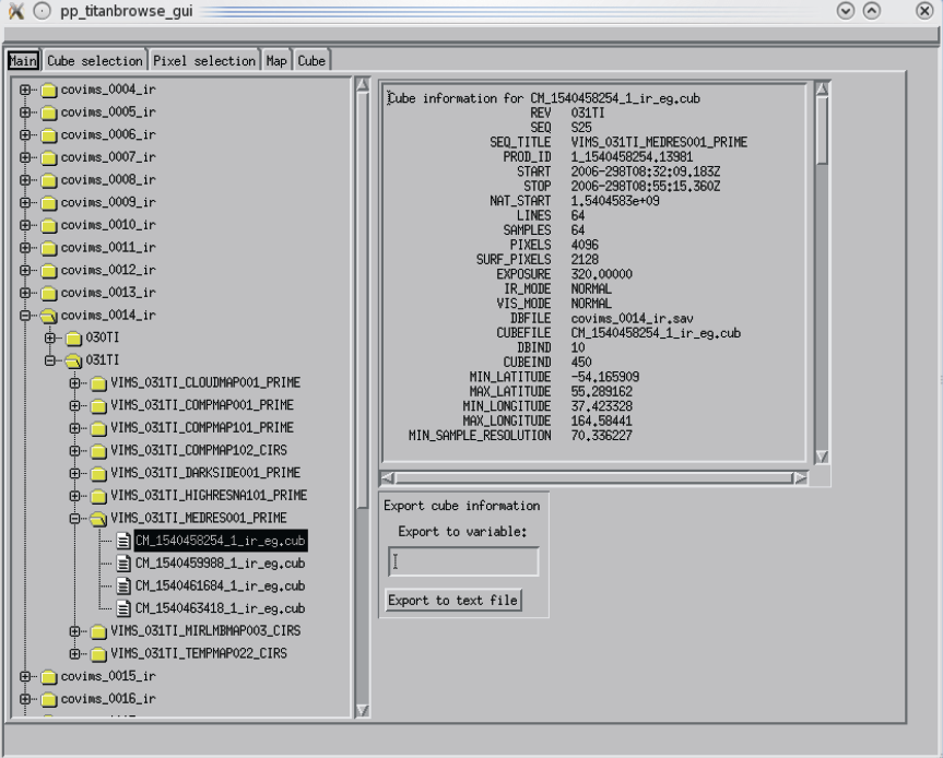
Graphical Interface and Visualization
In addition to the API, titanbrowse includes a full GUI:
- Cube Selection Panel: Define queries using metadata filters
- Pixel Selection Panel: Filter by spectral or geometric criteria
- Visualization Panel: View spectral plots or specific wavelength images
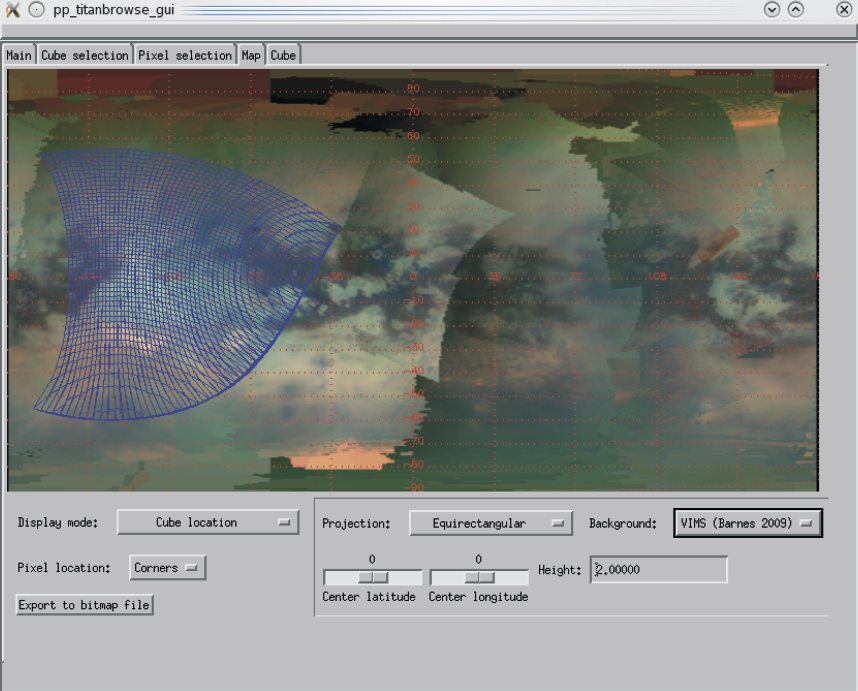
- Map Panel: View spatial coverage or display data on Titan’s surface
- Cube Browser Panel: Inspect metadata for all available cubes
Data from any panel can be exported for direct use in IDL or saved to disk.
Screenshots
Some Applications
titanbrowse enabled the discovery of the first tropical lake on Titan:
“Possible tropical lakes on Titan from observations of dark terrain”
Griffith, C.A., Lora, J.M., Turner, J., Penteado, P.F., Brown, R.H., Tomasko, M.G., Doose, L., See, C.
Nature 486, 237–239 (2012)
DOI: 10.1038/nature11165